Web Service Development |
Open Source Software Company | About Us | Contact Us |
Open Street Map
Open Street Map is an open data project which uses volunteers to collect geographical information from around the world and combines it into a freely hosted database.
The data is freely available and one of the most common uses is for tile-based map servers. These don't require any kind of license fee and can be customized internally for an orgranition. Though the Open Street Map project is specifically focused on the data, the time server is the result of serveral different programs that are combined in a way to produce the result of tile server.
This page includes diagrams and descriptions for what is generally considered to be the standard stack when it comes for hosting a map server.
OpenStreetMap サーバー構築
OpenStreetMapとは地理情報を管理するためのオープンデータプロジェクトです。
弊社では、OpenStreetMapのデータに基づいたマップタイルサーバのネットワークスタックをCentOS7で組み込みました。
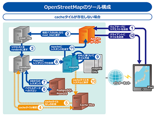
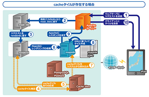
構成は右図で示す、Apache,mod_tile,renderd, Postgres,Mapnikのツールチェーンでの実装になります。
ハードウェアはIntel NUC(i5,16GBメモリ,256GB SSD)でテスト済みです。お客様に社内でご利用できるプライベートマップサーバを迅速に提供します。
GML変換サービス
国土地理院から公開されているXML型式のオープンデータをOpenStreetMapのマップサーバで利用可能にするGML変換サービスを提供します。
これによって国土地理院の地図の上にOpenStreetMapのタグ情報を付加したオリジナルなマップタイルを作成可能です。
オープンデータとしての国土地理院データは、国道等の道路種別が”不明”となっています。 従って、これらのデータが必要な場合は、日本地図センターからXMLデータを購入する必要があります。
対象環境
- OS : CentOS 7
- CPU : Intelのx86_64系
- メモリ : 8GB以上
- SSD : 120GB以上
- DB : Postgres
- クラウドサーバーを利用したオープンストリートマップ用サーバーの構築
- 用途に応じた生成タイル(地図画像)のカスタマイズ
- オープンストリートマップを用いた、iPhone/Android用アプリケーションの開発